|
Hurricane Katrina
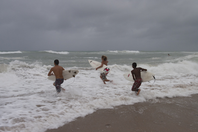
Tropical Depression 12 formed at 5 pm on August 23, 2005, in the Southeastern Bahamas. The forecast was for the depression to strengthen to a tropical storm moving northwest, with a gradual westerly course. That would have the storm crossing the South Florida coast between West Palm and Miami two days later. However, in their 5 pm discussion, the NHC noted that if a well defined center formed in 24 hours with central convection, "Katrina" could be a hurricane before landfall. The system continued to get better organized, and the next day at 11 am it was upgraded to Tropical Storm Katrina. Indeed, the environment was becoming more favorable, partly due to an upper level low southwest of Katrina that moved off to the west. I drove up to Fort Lauderdale from Big Pine Key not expecting much from Katrina. Normally I don't bother with tropical storms, but my experience has been that every storm offers up something unique. If you don't go, you might miss out. Besides, after Katrina crossed Florida there was always a chance it would strengthen back to a hurricane in the Gulf. On the forecast track, though, it didn't look like it would be over much water before hitting the Panhandle. Jeff Gammons also drove to the coast on the morning of August 25th. He came from central Florida to film Tropical Storm Katrina. His plan was same as mine – get into the right side of the storm to film the strongest winds and storm surge. Little did we know Katrina was going to be one of those historic events, and that it would last nearly a week. What started out as a lowly, disorganized tropical depression approaching the unimpressed Florida East Coast would balloon into a monster category five hurricane and become one of the most devastating natural disasters in US history. I drove up to Deerfield Beach, just north of Fort Lauderdale, around 1 pm. Tropical Storm Katrina was 40 miles east-northeast of my location with 65 mph winds, and moving west at a slow six mph. I immediately headed to my favorite spot to film - the shoreline - where the wind and the water meet. The wind is unimpeded over water, and crashing waves on the beach always makes for strong footage. That was where I wanted to be. The satellite trucks and news crews were out in full force, too. Reporters were filing updates and waiting for Katrina to get closer. I saw Jason Wheeler from WFOR in Miami again and said hello to him. Covering storms was a good gig - it got you out of the crazy office and gave you a chance to report on a real newsmaker. The storm was something everyone could relate to. No doubt the folks I was seeing on the beach had honed their storm reporting skills during the crazy 2004 season. Some stations had special storm crews, complete with custom painted vans. My favorite was a small satellite truck from Tampa that said "ABC Action News StormChaser" and had two 2x4s painted to look like they were protruding from the van. It wasn't hard to find the good spots to film - just look for the wall of bumper-to-bumper satellite trucks. Since Katrina was still a tropical storm there were no mandatory evacuations, and people just went about their business. Lifeguards still manned their lookout towers, but the only folks I saw in the water were diehard surfers, body boarders, and skim boarders shredding the shoreline break. The conditions would be deteriorating in a few hours, with an expected landfall around 7 pm. Nobody would be surfing in that at night, so they had to get it while the getting was good. I decided to grab the still camera and frame up three surfers getting ready to head out. I don't like getting near the surf with a still camera, but I could see a cool shot in my head with the big surf and stormy skies in the distance. It was worth it. So with a wide angle lens up close, I had one chance to nail the shot.
The 3 pm advisory came out, and the wind was up to 70 mph and had started to blow at nearly 30-40 mph along the coast. It's amazing the difference two hours will make as a storm approaches. I scanned the beach for a good shot, and saw the waves crashing into the pier pilings near the shoreline. If I got in close with the surge cam it just might work. The only problem was I was going to get hammered in the impact zone. I walked down with my surge cam and grabbed onto a piling, being careful of the razor sharp barnacles. Then I waited for a set. I looked through the LCD screen on the back of the cam and saw a series of waves rolling in and then crashing into the pilings, sending spray everywhere. Yeah, that's the shot I was looking for. The next series of waves were even better and one knocked me down hard, but I knew that would happen. Later I learned Elton John would use some of that footage in his Katrina benefit concert. At 5 pm, Katrina was a hurricane two hours away from landfall. The wind was blowing sand along the beach, making for very uncomfortable conditions. I took shelter behind some buildings and filmed the palm trees blowing in the wind. In my line of work, more often than not hurricanes are weakening when they come ashore. But not Katrina. She was getting stronger by the hour. I went down the street and saw a gas station overhang that was flapping in the wind. It looked like it just wanted to rip right off so I stayed with that shot for more than an hour and a half. It would have been what we call the "money shot," but it never panned out. It was getting dark by then, and I needed to start thinking about getting over to Naples and getting some daylight footage from there. I had a heck of a time finding the onramp for I-75 so I could go across the Everglades. It was dark, rainy, I couldn't see very far, and the wind was buffeting the car really hard. Constant lightning was turning night into day, which added to the driving difficulty. I was wishing I was in a house somewhere - anywhere but there. I finally found a deserted I-75 (Alligator Alley) and headed west to Naples. Now the only thing I had to watch out for was an alligator crossing the road - there were plenty of them in the adjacent swamps. Hit one of those and you have real trouble. During the trek across the Everglades, Jeff - who was back home by then - called me. He advised me that Katrina was moving southwest and would be exiting out the southwest tip of Florida in the morning. That was not good. It completely changed the forecast for Katrina. I decided to reroute to Jeff's place near Tampa and wait until we saw what Katrina would do next. Shortly thereafter, I received an email from NOAA saying there was a seat available the next day on the G4 Hurricane Hunter based at McDill AFB in Tampa. I went to Jeff's place for the night, happy to be out of the hazardous nighttime driving conditions. There was ferocious lightning, along with wind and rain - the toughest conditions I've ever driven in. In the hurricane filming business we say that if you see lightning in a hurricane that means it's strengthening. In fact, one of the Hurricane Hunter crew later told me it was much bumpier flying into Katrina just before she hit Florida than it was when she was a 175 mph hurricane in the Gulf. During the night of August 25th, Katrina continued to move slowly southwest over the Everglades. Less time over land meant the core would remain intact, and it would soon be back over very warm water in the Gulf of Mexico. As Katrina exited the southern tip of Florida, it quickly came back to hurricane strength.
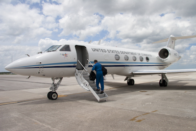
The next morning I drove out to McDill AFB, got my preflight briefing, and quickly jumped aboard the G4 - which was already mission-ready with its engines turning. The sampling mission consisted of flying a preprogrammed course at 40,000 feet around the perimeter of the storm for nine hours, during which the crew would drop 24 dropsondes. The dropsondes would measure pressure, temperature, humidity, and wind information. The data would then be relayed to the aircraft for transmission via satellite back to the National Hurricane Center. Next, the data would be used in the forecast models, providing an improved forecast track. On this particular flight the Flight Director was Paul Flaherty. The G4 is like flying a commercial airline. It's very smooth. We were careful not to get too close to Katrina, because the mission was to sample the steering environment around the hurricane. Paul Flaherty was at his monitor console amidships. He had a satellite link to the internet and had the Doppler radar up from Key West. We could see a heavy feeder band pounding the Florida Keys. I was regretting not putting up the shutters on my house in Big Pine Key. I would not make that mistake again. Throughout the day on August 26th, Katrina continued to move to the southwest. The movement meant that Katrina would spend a lot more time over the Gulf of Mexico, which was at its warmest all year, before making landfall as a possibly much stronger hurricane on the northern Gulf Coast. It was important to get the high altitude Gulf Stream jet up to sample the steering currents for the models - and hopefully in time for the 11 pm advisory. We landed back at McDill around 9 pm. During the flight, Katrina continued to move southwest and strengthen. The 11 pm advisory had the winds up to 105 mph with a new forecast track crossing Grand Isle, Louisiana, and then moving ashore near the Louisiana/Mississippi border as a category four hurricane. Katrina was ramping up quickly, and had plenty of time over very warm water. Our flight data was ingested in the 8 pm model run. At 11pm the forecast track by the NHC accurately predicted the center would cross near the Louisiana/Mississippi border in about three days. After the flight I edited the video I had shot and uploaded it to The Weather Channel. Then I headed back to Jeff's to regroup and recharge my batteries for the big push up to the central Gulf Coast. The next day we awoke to rather ominous wording in the NHC's 5 am discussion. Katrina had reached 115 mph and 945 millibars of pressure, and it was moving west at seven mph. But this was the scary part: "Katrina was located in an atmospheric environment that seemingly cannot be much more conducive for strengthening." In other words, Katrina was poised for what we call rapid intensification. We spent the day charging batteries and planning for the trip to Gulfport or Biloxi, both of which looked like they were right in the path to get the dreaded right-side eyewall and maximum storm surge. Early on Saturday, August 28th, I headed out for Pensacola to see my folks before continuing on to Mississippi. Jeff left a few hours later, after taking care of last minute preparations. Katrina continued to strengthen steadily - going from 145 mph at 4 am, to 160 mph at 7 am, and finally to a monster 175 mph at 10 am. While in the Gulf Katrina had also greatly expanded its wind field, with tropical storm-force winds extending out 230 miles from the center and hurricane force winds extending out 105 miles. It was the worst case scenario: not only a very intense hurricane, but also one that was exceptionally large. The stopover in Pensacola was a difficult one. My mom, glued to The Weather Channel all day, asked me not to go to Mississippi. She feared the storm was just too strong and dangerous. They were evacuating coastal Mississippi and New Orleans, and it just wasn't safe. I didn't have much wiggle room because, after all, a175 mph hurricane was off the scale and far more dangerous than any storm I had filmed - even Charley a year prior. I said, "mom this is what I do, I'll find a safe place - promise - and call you every 30 minutes." With that, I left her crying on the porch. I merged onto I-10 and headed west toward Mobile. To my surprise, the eastbound lane was bumper to bumper. Geez, I thought, we're not even close to Mississippi, and already it's a traffic jam. It was a 100-mile line all the way to Gulfport and beyond. I didn't know at the time, but the NWS Office in New Orleans had issued their "Doomsday" forecast and it had a chilling effect on coastal residents.
The only good thing about driving into a hurricane is that there's no traffic. My westbound lane going toward Mississippi was virtually empty. It was clear sailing all the way to Gulfport. Several times I stopped and filmed the eastbound lane. It was just crawling along. I felt bad for those folks who were leaving their homes, only to end up stuck in traffic for hours and hours. Where were they all going to go? No doubt the motels would all be booked for several hundred miles, some wouldn't take pets, and many would probably be charging extra. There had to be a better plan. I thought if it were me, and the water couldn't get in my house, I'd just stay put. Then again, if your roof comes off you'd wish you had evacuated with everyone else. I rolled into Gulfport at about 6:30 pm and started looking for a safe structure. Most of the people had evacuated, but I was surprised at just how many had stayed. No doubt some of them were battle-hardened by Hurricane Camille on that fateful day - August 17, 1969. One of only three category five hurricanes to hit the US, Camille was the benchmark there in coastal Mississippi. In 1990, I had driven to Biloxi just to talk to strangers on the street about what it was like the night Camille had come ashore. Everybody had a fascinating storm surge story to tell. Camille was a small but powerful hurricane that killed 256 people and flattened the famous Richelieu Apartment building, which was right beside Highway 90. With that thought in mind, I turned right onto Hwy. 90, looking for a safe place ride out the storm. How do you find a secure location to film in a category five hurricane? A parking garage would do, but then you have all that rain blowing through and you're still going to get wet. I looked at the Air Force Retirement Motel and while it was "high and dry" I didn't like the idea of the locked gate after you went in. You never know when you might have to get out. I went west to Waveland and Pass Christian, Mississippi and those places were really scary - no safe place anywhere. It was getting dark and I was getting anxious. I needed to find a solidly-built structure above the maximum storm surge and just couldn't find anything. I was going swimming if I stayed anywhere in that area. So I turned back east toward Gulfport and Biloxi. At least there were better looking structures there. And then I got lucky - on the way back to Gulfport I found an open gas station with just a few cars in line. What gold. I topped off my tank so I would have plenty of gas to drive back to Pensacola after the storm. It's so important to have plenty of fuel after a storm - so much so that you don't mind smelling a couple of five gallon jugs of it in your truck or back seat. Many times I've found the best place to fuel up is not en route to the hurricane, but at a gas station at ground zero. I went all over Gulfport and Biloxi looking around - and I found nothing. Then I saw a parking lot to the north with a big round structure. I've always liked round structures since they do very well in strong winds. For example, about the only structure intact after Hurricane Andrew hit Homestead, Florida was the water tower. I had driven up on the Coliseum, located about 600 feet from the ocean between Gulfport and Biloxi. It would be ideal. I drove over to the north side and notice cars parked there, along with some people milling around. Maybe they planned to ride it out? I walked over and met the director of the Coliseum, Bill Holmes, who let me stay there with a warning that it was going to flood even at 26 feet above sea level on the north side. Nonetheless, about 50 people decided to ride out the storm at the Coliseum. I remember thinking, 26 feet? No way would it flood. Camille didn't even come up that far. But just in case, I could always move my vehicle up one of two ramps leading to the second floor level. Before I got too busy I made a quick phone call to mom and told her where I was and that it was a secure building. She sounded much better on the phone, and said she knew where I was, as Jim Cantore with The Weather Channel had been at the Coliseum earlier in the day with live updates. I told her about the ramp, how I had driven up to stash the car, and that there were 50 other people there with me. Mom was a bit more relaxed then, knowing I was safe and that I wasn't alone. At about 11 pm I called Jeff Gammons, who had left several hours behind me. He'd had no luck finding a safe location to film since he had rolled into the area at 9 pm. He'd been all over the Gulfport/Biloxi area too, and everything was either closed or just not safe. I told him if he couldn't find a good spot to join me at the Coliseum, it was a fortress. Jeff showed up and looked over the area well and decided it was secure enough to stay. We brought all the gear in and stored it in a small concrete reinforced room on the second floor. We set up our laptops on a table on the ground floor with the Doppler radar running continuously, thanks to those Sprint data cards. Then, all we had to do was get some sleep. Power was still on in the Coliseum. One of the security guards let me into his air-conditioned monitoring room where there was a couch. I tried to get some shut-eye, but I was just too wound up to relax. I had been thinking about category five Katrina ever since I had left the Florida Keys five days before. After an hour of tossing and turning I gave up and went back out to check the Doppler radar running on the laptop. Instead of the symmetrical appearance it had before, the west side of Katrina had started to erode and the eyewall was beginning to open up on the south and southwest sides. I suspected some dry air was getting sucked into the storm, since that wasn't uncommon with northern Gulf of Mexico hurricanes. At 4 am the winds dropped to 150 mph and the pressure was 915 millibars - as strong as Charley had been a year earlier. Jeff was still up, too, and we discussed the impact of the west side eye opening up and how much Katrina would weaken. Sometime thereafter, the power went out for good. Daybreak finally came, and Jeff and I headed to the south side of the Coliseum to take a look. It was hard to see what was happening on the beach road but we could hear it. My low-light camera's viewfinder showed waves breaking on highway 90 with a 60-70 mph wind blowing everything east to west right down the road. The winds were strong, but I knew it might be my only opportunity to film the shoreline action up close. I grabbed the surge cam and headed down to the shoreline, careful to walk upwind of a wobbling street light while Jeff filmed me from behind the safety of a vertical support piling. I had trouble standing upright in the increasing wind. Hwy. 90 was completely covered up with a violent ocean. I backed away and filmed progressively larger waves. The wind blew at hurricane force and my skin tingled with danger. I was really pushing my luck by venturing down there to the danger zone where the wind, water, and land converged, to get that shot. After a few minutes a large piece of airborne plywood landed in the water in front of me, making a big splash. Simultaneously, a structure collapsed from the storm surge nearby. Time to go! I immediately spun around, sprinting back to the safety of the Coliseum. Jeff was taking it all in. We had both been in Hurricane Charley, a powerful but small hurricane. Katrina was a category five less than 12 hours before, and much larger that Charley had ever been. While Katrina was weakening, I wondered what effect that would have on the storm surge. It wouldn't take long to find out. The wind began to shift around, blowing more and more toward the Coliseum - and with it came the ocean. It picked up everything in its path, too. I saw a 25-foot fiberglass boat come up the road and knock over a light pole. All sorts of debris was coming up the road - just one huge pile of junk. As the waves started lapping up against the south side of the Coliseum I had to abandon my shooting position and go to the west side. The ocean was really coming up fast. In a matter of minutes I had to move from there, as the water was almost up to my knees. I stepped on a nail in a board and felt it go in deep. That was what I got for staying out in the elements trying to capture the storm surge. I high-stepped my way back to the north side of the Coliseum, which was higher, opened the door, and went inside. The water followed me. Jeff was inside, filming the water coming down the hall. "Are you ok?" he asked. I told him how the water came up so fast and it was really hard getting back to safety, plus I stepped on a nail while carrying the tripod/camera and a surge cam. I thought I should try to shut the door and stop the water from coming in, but Jeff said, "it's coming in from all over - don't worry about it. There's nothing you can do. But you better get your car up the ramp. It's already a foot deep outside." I turned around, put my gear down, and trudged back out through the floating debris. I jumped in my car and moved it halfway up the ramp behind another vehicle with only seconds to spare. The other eight or nine vehicles on the ground were going to be ruined. I left the keys in the ignition in case that scenario developed and it's a good thing, because I only had seconds before the water would have saturated electrical components in the engine compartment – and that's when you can kiss your vehicle goodbye. We quickly moved our laptops upstairs before they, too, became storm surge casualties. Folks all over the first floor started moving their belongings up the flight of stairs, as well. Many people thought just like I did, that the water wouldn't really get up that far. Well, we were all believers then. The storm surge was building up so quickly that there was three feet of water outside the glass. Eventually the water level outside and inside equalized and Katrina really started beating up the Coliseum. The windows broke, including the metal frames, and cars outside started to float - their flashers and horns coming on. Jeff and I were scrambling all over the Coliseum filming the onslaught. The water couldn't reach the second floor, but the 125 mph wind blew out the second floor windows on the south side. I thought the Coliseum was the safest structure along the coast, but I was beginning to doubt that. The interior of the Coliseum was starting to fill up with salt water. I saw a man carrying a heavy wheelchair from the first floor up the stairs as the water level on the first floor got higher and higher. Furniture started floating and would make a lap all the way around the Coliseum. Upstairs, dogs were barking and worried folks wondered just how high the water was coming up. Nobody had ever seen the ocean that far inland. Bill Holmes gathered everybody together and gave them an update on the hurricane. We had only been through the first half, and already Bill had information that people had died. One lady turned away and said, "Oh Lord, I didn't need to hear that." Bill said if the water came up to the second floor we'd go up top. I'm not sure what "up top" was, as we were as high as we could go, I thought. He also said we should stay off our cell phones and conserve battery power – we were going to need it. Cell towers had battery backup for 24 hours - but only if they weren't damaged. One lady looked out the window on the north side as if she was looking for something then let out a startled "that's my car!" Her car was floating and bouncing into the other cars, flashers blinking - a sure sign the electrical system was shorting out. It was a goner. I went to the center of the Coliseum. It was dark, and after my eyes adjusted to the low light I realized I was looking at one giant salt water pond. Light came in through a door, and the wind was howling through it, as well. I saw a family hide behind it and then bolt across to get to the other side. The storm surge on the first floor had a heavy fuel odor to it, and we cautioned people who were smoking not to get too close or throw their cigarettes in the water. The last thing we needed to deal with was a fire or an explosion. That would have spelled doom for all of us. It was so bad that I didn't even venture into the water to film. There was no telling what I could catch, as that water was nasty stuff - not to mention my foot was still hurting from the nail earlier. I remember seeing a brown dog tied up upstairs in the hallway looking out a door that had blown open in the howling wind. He was really scared, and no doubt heard all sorts of strange and troubling noises with his super hearing. Pets seem to know what's happening. He just stared out the door into the howling wind and barked. I went over there and cuddled him and said, "hey it's gonna be all right." He was shaking all over. His tongue was dark blue – I didn't know why, and never did find out. At least we were up high, and that made us safe from the storm surge. There were other folks who stayed in houses for whatever reason - maybe thinking Camille didn't come up that far so there were safe. The storm surge went well past the Coliseum, and if it carried a big tree or piece of debris then that would act as a battering ram on the house. I saw a huge tree trunk inside the lobby of the Coliseum on the south side. As Katrina moved inland, the wind shifted out of the west. We never experienced the eye because it moved ashore near the Louisiana/Mississippi state line. Since the wind was no longer blowing from the south, all that water that had been pushed up onto the shore started to recede. I was on the south side of the Coliseum and filmed the water running back out toward the ocean. Eventually, the rain let up and I could see a little bit in the distance. I was up on the second floor, and one guy said "hey, you have to see this." We walked down to a door that had been blown open and I looked out toward the southwest. I didn't see anything. He said, "no, you don't understand. That's the President over there." I asked what he meant, and he said it was the President Casino barge. It didn't belong there; it belonged a mile away. It had broken its mooring and drifted there, landing on a Holiday Inn. It was huge. I saw Jeff in the concrete bunker room where we had originally put all our gear. It was dark in there and I turned my head lamp on. Jeff was slumped over in a chair, totally drained, doing a portable kidney dialysis. You really have to love filming hurricanes to go through that. I had noticed that Jeff had slowed down a bit that season, but I hadn't known why. I learned that both his kidneys were failing and he was on a list to receive a kidney transplant. Meanwhile, he kept doing what he loved - filming storms. When the water receded, people started venturing outside. The residual wind was still blowing pretty hard, making it difficult to steady the camera even on a heavy fluid-head tripod. The first thing I did was walk over to the President Casino barge. It was massive. The surge had deposited it there, but the wind really did a number on the inside. It was totally wrecked, looking as though it went through a metal shredder. I wasn't the first to get down to the barge, either. I don't know where they came from, but looters were digging through the sand for quarters and tokens. Then they started working together with someone up in the barge who was tossing down the busted-up coin canisters from the slots to someone on the ground with a five-gallon bucket. It seems like after every bad hurricane there's always a few people that want to take advantage of the situation. Jeff decided to drive out and get back home to central Florida if he could. I was going to stay and film for a few days initially, but after sizing up the situation - lack of power and no clean drinking water - I decided to leave an hour later. The destruction I saw along the coast convinced me that the area was going to be locked down, and I didn't want to get in the way. I had to remove a lot of debris behind my SUV on the ramp. I was amazed that even halfway up the ramp, debris came up to the back of my vehicle. It took a good 30 minutes to clear everything. If I was lucky and didn't run over any nails, I'd make it out of there. I chose to drive right down to the beach road and find Hwy. 49 north. The beach road was all torn up, and very tricky to drive over. I met a couple of local guys out sightseeing in a 4x4 and asked them if they could help me find a way to get out of there. "We'll find you a way," they said with assurance. We took a lot of side roads, went behind the Edgewater Shopping Center (which had a distinct watermark on it), and sure enough I found Hwy, 49, the road leading back to I-10. Along the way, I stopped on a bridge and filmed some shrimp boats tied to shore on a river. Some made it through ok, but two of them were turned on their side and half out of the water. I made it to I-I0, which had only one lane open. There were no police anywhere and the eastbound lane was used for both directions. It was really dark and you couldn't tell if the car coming at you was on your side of the road or not. I wanted to make it back to my folks' house in Pensacola - a two-hour drive normally. I was so tired from lack of good sleep and pushing myself during the hurricane filming trip. The thought of a nice warm bed and electricity kept me going. The most dangerous part
of my Hurricane Katrina encounter was upon me - the drive back home. Near
Spanish Fort, Alabama I stopped to get some no-doze pills. They didn't
have any effect on me. I struggled with staying alert, but finally rolled
in to my folks' place. They were up waiting for me. Mom said I looked
tired, but she was relieved I made it back. I told her it was pretty bad
back there and then went straight to bed, collapsing into a deep sleep.
When I woke up my dad was watching the news and I asked what was
happening. He said the levies had failed and Lake Ponchartrain was
flooding New Orleans. Another disaster was just starting.
Video is suitable for all Ages!
|